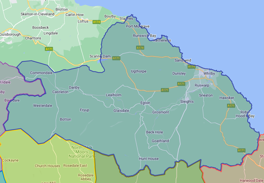
The District
Whitby Community Network CIC tries to cover the whole of the area typically referred to as Whitby and District, or the Whitby Travel-to-Work-Area (TTWA) – see the map below. This aligns very approximately with the following NYC Wards (councillor in parentheses, hyperlinked to email)
- Whitby Streonshalh (Cllr Neil Swannick),
- Whitby West (Cllr Phillip Trumper),
- Esk Valley and Coast (Cllr Clive Pearson), and
- Danby and Mulgrave (Cllr David Chance).

Including the parishes represented by the following councils (hyperlinked to council website) :-
- Whitby Town Council,
- Aislaby Parish Council,
- Danby Group Parish Council,
- Egton Parish Council,
- Eskdaleside-cum-Ugglebarnby Parish Council,
- Fylingdales Parish Council,
- Glaisdale Parish Council,
- Goathland Parish Council,
- Grosmont Parish Council,
- Hawsker-cum-Stainsacre Parish Council,
- Hinderwell Parish Council,
- Lythe Parish Council,
- Mickleby Group Parish Council,
- Newholm-cum-Dunsley Parish Council,
- Roxby Group Parish Council,
- Sneaton Parish Council,
- Ugthorpe Group Parish Council.
Age Demographic
Whitby and District has a typically aging population, with falling school subscription rates. The age demographics of representative parish council areas are shown graphically below (only some parish councils are shown, for clarity purposes). As seen, the district is below average for the percentage of younger people, and above average for elderly age groups. The data is taken from the 2021 Census.
In tabular form, with actual population figures and for all parishes in the district, the data shown above is represented as
| Parish Council | 0-19 Years | 20-29 Years | 30-39 Years | 40-49 Years | 50-59 Years | 60-69 Years | 70+ Years | Total | |
|---|---|---|---|---|---|---|---|---|---|
| Whitby | number | 2372 | 1181 | 1420 | 1431 | 2017 | 2123 | 2610 | 13154 |
| % | 18 | 9 | 11 | 11 | 15 | 16 | 20 | ||
| Eskdaleside | number | 334 | 153 | 178 | 192 | 366 | 436 | 603 | 2262 |
| % | 15 | 7 | 8 | 8 | 16 | 19 | 27 | ||
| Hinderwell | number | 329 | 150 | 159 | 170 | 291 | 285 | 400 | 1784 |
| % | 18 | 8 | 9 | 10 | 16 | 16 | 22 | ||
| Danby Group | number | 220 | 127 | 147 | 142 | 245 | 284 | 362 | 1527 |
| % | 14 | 8 | 10 | 9 | 16 | 19 | 24 | ||
| Fylingdales | number | 227 | 71 | 98 | 109 | 185 | 245 | 313 | 1248 |
| % | 18 | 6 | 8 | 9 | 15 | 20 | 25 | ||
| Glaisdale | number | 168 | 71 | 92 | 89 | 195 | 169 | 199 | 983 |
| % | 17 | 7 | 9 | 9 | 20 | 17 | 20 | ||
| Hawsker cum Stainsacre | number | 114 | 49 | 61 | 72 | 134 | 100 | 174 | 704 |
| % | 16 | 7 | 9 | 10 | 19 | 14 | 25 | ||
| Egton | number | 101 | 30 | 44 | 63 | 83 | 71 | 72 | 464 |
| % | 22 | 6 | 9 | 14 | 18 | 15 | 16 | ||
| Goathland | number | 31 | 25 | 20 | 39 | 69 | 84 | 106 | 374 |
| % | 8 | 7 | 5 | 10 | 18 | 22 | 28 | ||
| Lythe | number | 40 | 22 | 22 | 30 | 66 | 72 | 92 | 344 |
| % | 12 | 6 | 6 | 9 | 19 | 21 | 27 | ||
| Grosmont | number | 30 | 25 | 17 | 27 | 52 | 75 | 69 | 295 |
| % | 10 | 8 | 6 | 9 | 18 | 25 | 23 | ||
| Mickleby Group | number | 46 | 12 | 13 | 32 | 42 | 45 | 65 | 255 |
| % | 18 | 5 | 5 | 13 | 16 | 18 | 25 | ||
| Aislaby | number | 29 | 18 | 21 | 24 | 46 | 61 | 46 | 245 |
| % | 12 | 7 | 9 | 10 | 19 | 25 | 19 | ||
| Ugthorpe Group | number | 50 | 25 | 25 | 26 | 45 | 44 | 30 | 245 |
| % | 20 | 10 | 10 | 11 | 18 | 18 | 12 | ||
| Roxby Group | number | 31 | 16 | 14 | 24 | 38 | 37 | 37 | 197 |
| % | 16 | 8 | 7 | 12 | 19 | 19 | 19 | ||
| Newholm-cum-Dunsley | number | 32 | 19 | 11 | 22 | 34 | 37 | 39 | 194 |
| % | 16 | 10 | 6 | 11 | 18 | 19 | 20 | ||
| Sneaton | number | 30 | 13 | 26 | 24 | 26 | 30 | 45 | 194 |
| % | 15 | 7 | 13 | 12 | 13 | 15 | 23 | ||
| England (average) | % | 23 | 12 | 14 | 13 | 14 | 11 | 13 |
In accordance with our transparency policy, this table is downloadable in spreadsheet format.
