Harbour, River and Coast
In what is often collectively called “Blue Space”, we consider the following
- Whitby Harbour – the sole harbour in North Yorkshire with a river flowing out into the North Sea.
- The Fight4Whitby court case for all proceeds of the harbour land (including car parks) to be ring-fenced to maintain the harbour.
- Harbour maintenance, and highlighting the various aspects needing improvement.
- Harbour dredging – an essential activity to prevent silt build up that would halt harbour operations.
- A brief history of the harbour and the various acts of legislation that apply.
- The River Esk.
- The Coast.
- Flooding – the risk of both fluvial (rover) flooding and tidal flooding (as well as the joint impact).
- Future Development ideas for the harbour, river and coast.
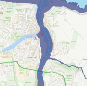
The map below shows the harbour land boundary (blue outlined shaded area), from WUDC land ownership documents (as was respected by SBC until around 2005), and as agreed by Justice Sweeting in the harbour court case in 2024. It also shows the Environment Agency classifications for coastal erosion for the coastline.
If this map does not show, please click here for a Google Maps version.
The harbour boundary definition is also downloadable in Keyhole Markup Language (KML) and GeoJSON formats, as follows : KML | GeoJSON.
Whitby Harbour
The Whitby harbour area is the central amphitheatre of the town. It is the primary area visited by the many tourists coming to the town, as well as being an integral part of the work in the town.
A local government Act in 1905, the Whitby Urban District Council Act, required that all revenue generated on harbour land should be retained “ring-fenced” for maintaining the harbour. When Scarborough Borough Council (SBC) took over from Whitby Urban District Council (WUDC) in 1974, the terms of this Act fell on them, and they maintained separate accounts for the Whitby Harbour area until between 2000 and 2005. Thereafter, harbour revenue was not ring-fenced, and was spent across the Borough. SBC have under-invested in the Whitby harbour area for years.
Some examples of underinvestment
- The Tourist Information Centre was closed in 2015. For a resort with over 3 million visitor days per year we consider it unacceptable to remove it from this prime location.
- The piers, extensions and quays have been in urgent need of repair for years. See below for reports into their status.
- Facilities for landing fish are lacking, meaning that trawlers land their catch elsewhere.
- Fishing parties have next to no facilities to use when returning.
- NYC is pocketing the order of £800k / annum in car parking fees.
- The east pier had to do without a connecting bridge to the extension for 20 years before it was finally replaced (cost £300k, with £120k coming from the Whitby Town Council because SBC refused to fund it).
Fight for Whitby Harbour court case
Starting in 2015 there was a dispute regarding the revenue generated on harbour land in Whitby harbour. This was fought by the Fight4Whitby campaign. In researching the background to the ring-fencing of harbour funds, it was discovered that income from Whitby harbour appeared to have been reserved for harbour use until some point between 2001 and 2005 when it stopped. During this period Scarborough Council had severe financial problems because of a £30M overspend on a coastal project in Scarborough. It was also identified that the actual surplus from the Whitby Harbour undertaking, including the car parks on harbour land, was in excess of £1.2M for the accounting year 2015/16 alone. Clearly, such an annual income would make a huge difference to the funding needed for the repairs to the piers over the next 20 years.
The 1905 Act, which requires all revenue obtained from harbour land to be ring-fenced for use on maintaining and developing the harbour, had seemingly not been upheld since around 2005. SBC, and now NYC, also questioned the extent of Whitby harbour (SBC claimed that Marina car parks and Endeavour car park are not on harbour land, despite being on reclaimed land owned by WUDC). As a result of this case, financial accounts for SBC were not been signed off since 2015. When SBC was abolished this fell upon the new North Yorkshire Council.
The case finally reached the Royal Courts of Justice in London on 5th-6th March 2024 (Hon Mr Justice Sweeting). The court needed to determine
- How should the 1905 Act be properly applied in these circumstances?
- What is the extent of the harbour land? hence defining what revenue has been obtained on harbour land.
- Dependent on the first 2 questions, NYC should then have to move all funds from past years obtained from the defined harbour land into a ring-fenced harbour account, available for use in maintenance and development of the harbour.
The verdict was provided to the objector (Mrs Sue Boyce) on 14th March 2025, ruling in her favour on all points.
It should be noted that this ended up in court due to SBC apparently “not knowing” the boundary of harbour land, and requesting that a judge resolve the dispute (despite seemingly accepting the more common interpretation of harbour land as including marina car parks and Endeavour Wharf car park up until around 2005). The defendant in court was a retired Whitby and district resident who had the temerity of questioning the councils “interpretation” and who had to do this at their own expense (due to the external auditor, Mazars, not being willing to resolve it). SBC (and then NYC) utilised tax payers money for their legal expenses (and having spent around £280k up until the end of 2022-2023 financial year). Where is the fairness in this situation?
This was covered extensively in the media, including the following
- Yorkshire Post on page 1 and page 8 by Alexandra Wood on 17/02/2024.
- Responded to in the letters section of the Yorkshire Post on 29/02/2024.
- BBC Look North on 04/03/2024.
- ITV Calendar on 07/03/2024.
- Yorkshire Post on page 5 by Alexandra Wood on 09/03/2024.
- Sunday Times by Hannah Al-Othman on 10/03/2024.
- The judgement was covered exclusively in the Yorkshire Post by Alexandra Wood on page 6 on 15/03/2025 and on page 5 on 20/03/2025.
Harbour Maintenance
2002 – A report by High-Point Rendel estimating a residual life for the piers of 10 years.
2009 – A report, Whitby Coastal Strategy – Further Investigations at Whitby Harbour, by Royal Haskoning in 2009 revealed major deficiencies in the maintenance of the east and west piers and extensions. You can find this report HERE, and its appendices HERE.
2012 – A further report, Whitby Coastal Strategy 2, by Royal Haskoning in 2012 is also available HERE with related info HERE.
The poor levels of maintenance of piers and extensions presents the severe risk that one of the extensions will fail, and likely block the entrance to the harbour. The below figure highlights the profound impact that the extensions (and piers) have on the water (and potential flooding) within the harbour area. It doesn’t take much imagination to think of the potential consequences of one or both extensions failing.
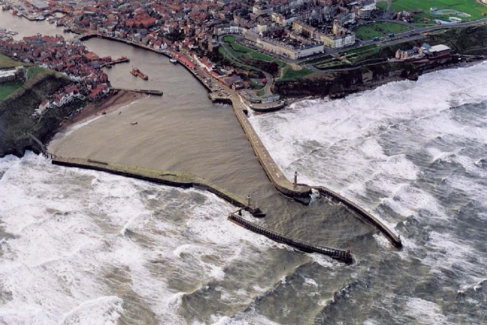
As highlighted in an SBC report to their Cabinet in 2011, the consequences of closing the port would include:
- Risk to life : some 15-20 vessels take unscheduled refuge in Whitby harbour each year in storm conditions. The RNLI station would be unable to leave harbour to respond to emergencies at sea.
- Risk to property : some 500 homes and businesses around the harbour would be at significantly increased risk of flooding from wave and tide action. These include two Grade 1 buildings; four Grade II* buildings; and over 200 Grade II listed buildings.
- Impact on tourism and the environment : As the Whitby Coastal Strategy 2 identified: “The loss of the harbour piers would adversely affect the geological SSSI and 2 conservation areas. There would be loss of tourism and amenity value which is irreplaceable due to the unique tourist appeal of key cultural assets and the iconic location of the Abbey and harbour setting.“
As a result of these reports, the major works on the main piers, costing around £8.5M, were supposed to be completed by 2018, with up to a further £20M of works to the pier extensions needing to be completed at the latest by 2031 (but brought forward if problems were detected).
By 2016, none of this work had been scheduled and the harbour was in a dreadful state of disrepair. Vessels were running aground because of insufficient dredging and the local trawler owners had stopped landing fish in Whitby. Yet a working harbour is central to the whole economy of the town, both as a port and marina operation and as its key tourism attraction. The first phase of work, to repair the piers, was finally completed in 2020. There is still no plan (nor funding) for the work on the extensions. Additionally NYC decided to go ahead with the building of a “Maritime Hub” on Endeavour Wharf (which would be needed as a compound for the required works on the extensions).
We have tried to document, using photo evidence, the many problem areas of harbour maintenance on a separate page. Well worth a glance to understand the scope of the underinvestment.
Whitby Harbour Users Group
It needs mentioning that there is a Whitby Harbour Users Group, supposedly of users of Whitby Harbour, as a forum for consulting about any changes. Given that this group does not abide by openness and transparency, and doesn’t publish their meeting deliberations, maybe it doesn’t cater for all harbour users needs? An FOI in April 2025 revealed that it only has very limited admittance (and so not being for all harbour users, just a select few). The FOI provides access to the terms of reference to the group as well as their meeting minutes between 2021 and 2025.
The minutes of meeting of this group are to be found HERE.
Harbour Dredging
Sand is generally transported west to east along the coast between Sandsend and Abbey Cliff. Some sand is transported past the west pier and settles on a bar near the harbour mouth. A significant proportion of sand and some shingle is transported into the harbour settling in the lower estuary (downstream of the Swing Bridge). Finer material is transported further upstream settling beyond the Swing Bridge. The harbour needs to be dredged regularly to a schedule. Without this, sediment will build up and prevent entry and exit from the harbour. Where this affects the lifeboat there will be an impact on life.
Dredging has been going on in Whitby harbour since before the 1950s. The maximum tonnage of sediment to be dredged per year was set at 98000 tonnes until 2011 when it was reduced to 49000 tonnes “for commercial reasons”. In the Royal Haskoning report of 2009 it stated that between 1992 and 1999 the average dredging of sand from the area beyond Swing Bridge was around 23000 tonnes, and the average dredging of silt from beyond the Swing Bridge was the order of 48000 tonnes. In total, this made an average of 71000 tonnes per year.
In terms of the locations to be dredged, the following diagrams are from the licence to dredge registered with the MMO. Depths specified are relative to the “chart datum”.
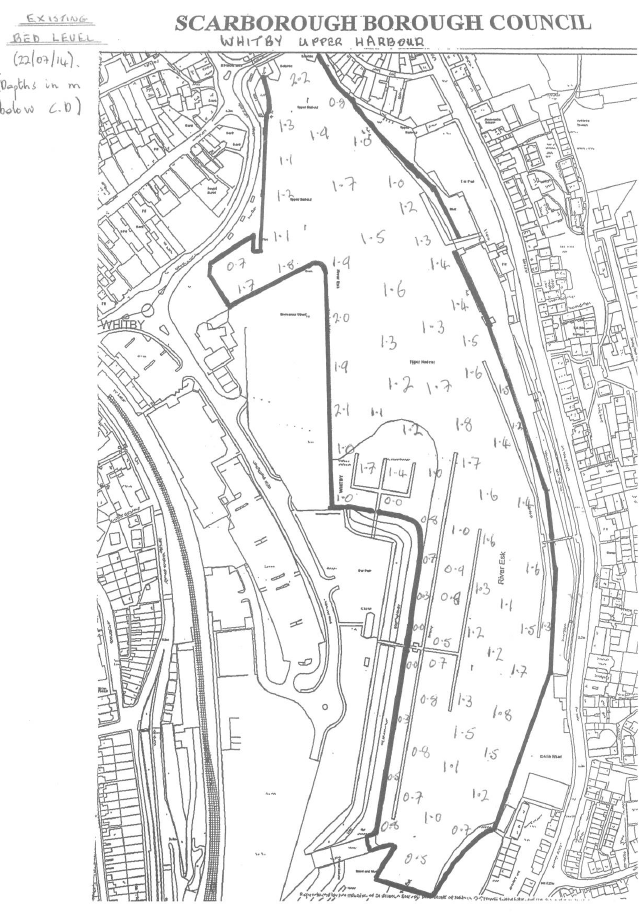
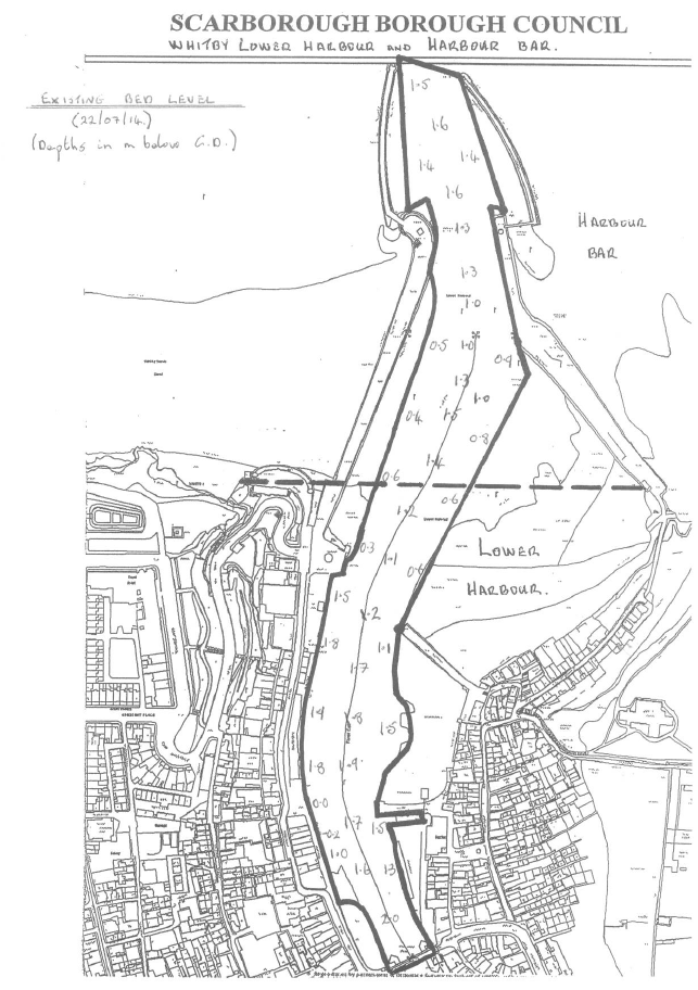
The actual sounding levels in Oct 2023 / Feb 2024 are shown on this post, from an FOI.
The following chart shows dredging quantities for the most recent years. Clearly 2023 was a particular issue (including dredger Sandsend leased to Dalby Offshore, followed by their fall into receivership etc), and the sediment will now have built up further. There ought to be a plan for catching up with what was missed during 2023. Ought to be … but sadly NYC forgot to renew their dredging licence with the Marine Management Organisation and so no dredging happened in 2024, with the licence only being provided on 19th June 2025. The final sounding survey before the dredging recommenced was in April 2025 [link].
Readers should be aware of what NYC say about Whitby Harbour on their website. As of May 2024 this states “vessels of up to 3000 tonnes DWT (LOA 85m, Beam 14m, Draft 5.0-6.5m) can be handled at Endeavour Wharf with the capability to handle 2 of these vessels simultaneously”. Additionally “Vessels with larger dimensions would be considered on an individual basis subject to equipment levels and handling characteristics”. With the sediment levels in May 2024, these claims are peculiar. The webpage does mention “5000m² of open quay storage available on the wharf” – clearly if there is construction of a “Maritime Hub” on that wharf then the square metrage will have to be reduced substantially.
History of the Harbour
- St Hilda and the Synod of Whitby 664 AD, first put Whitby on the map. By the early 1300s, wine from Lombardy and goods from all over Northern Europe were imported to supply the wealthy Abbey. The natural harbour had been improved with quays, a bridge and a pier, to shelter the harbour from the full force of the North Sea. Interestingly, coal was shipped to the Abbey from Sunderland as early as 1392 – the first record of the trade that was to make Whitby’s fortune.
- Alum shale was found locally and from the early 1600s, larger sailing ships were built to meet the transport needs of the local alum works. Whitby’s ship-building and repair industry expanded rapidly, driven by demand from the alum trade and the shipping of coal from Newcastle to London. Such was the growth that by the early 1700s Whitby ships were sailing regularly to the Baltic to secure the raw materials for ship-building, sail and rope-making. At its peak in the 1790′s, Whitby vied with Newcastle to be the second largest producer of merchant ships, after London. The wealth of the town is reflected in its built heritage from this period.
- Whitby was a much needed port of refuge for ships sailing along the exposed Cleveland (=cliff land) coast. From 1702, improvements to the piers and harbour were financed by a ‘passing toll’ levied on every shipment of coal from the Tyne ports, past Whitby, to London and other ports.
- It used to be said that ’the only road to Whitby is the sea’. Crossing the wild uplands of the North York Moors was perilous until the first turnpike road was built in 1764. Thus, while many towns centre on a market square, Whitby’s focal point is its harbour. The estuary of the River Esk was the only natural harbour in the 100 miles (160 km) of exposed North Sea coast between the rivers Tees and Humber.
- The market for wooden vessels dried up and the passing toll was finally abolished in 1861. The loss of income led to the harbour falling into a state of total disrepair. The competing interests of the Lord of the Manor, the North Eastern Railway Company, and the Harbour Trustees defeated all attempts to reach agreement on proposed improvements.
- Whitby Urban District Council (WUDC) was formed in 1894. It purchased the harbour rights from the Lord of the Manor and took control of the harbour. Thus, after two centuries of governance by a Board of Harbour Trustees, Whitby became a municipal port in 1905. Funds for the essential and long-overdue harbour improvements could then be borrowed against the security of the local rateable income.
- Though not without controversy about the impact on the rates, major investment made over the next 60 years included deepening the channel to 2m; the construction of new quays; major repairs to the piers and the addition of the pier extensions; renewal of the swing bridge; rebuilding and extension of the Fish Quay; and the construction of Endeavour Wharf for cargo handling on reclaimed land in the Upper Harbour.
- The 1974 re-organisation of local government led to the former Whitby Urban and Rural District Council areas becoming part of SBC. Thus SBC became the Statutory Harbour Authority for the Port of Whitby.
- The town’s isolated position meant there was little to replace ship-building as the mainstay of the local economy – a role now filled by the tourist industry. The population has not increased since the 1800s so, apart from new housing on the outskirts to relieve overcrowding, the town retains its historic ambience. Climbing the steep cliffs to either side of the harbour, the tiered ranks of the ‘amphitheatre’ allow almost every dwelling in the town centre to enjoy a view of the harbour from some window, yard or alley-way.
Local Legislation
North Yorkshire Council is the Statutory Harbour Authority for the Port and Harbour of Whitby. Its various powers and duties are set out in the local Acts applicable to Whitby Harbour
- The key local Act of Parliament governing Whitby Harbour is the Whitby Urban District Council Act 1905. Other relevant local Acts include the Whitby Port and Harbour Act 1827, the Whitby Port and Harbour Act 1879, the Whitby Port and Harbour Order 1881 and the Whitby Port and Harbour Order 1883.
- The 1964 Harbour Act removed the need to enact further local Acts of Parliament, by allowing changes to local legislation to be made by applying to the Minister for a Harbour Revision Order. There has not been a Harbour Revision Order for Whitby Harbour since the 1964 Act, so the provisions of the Whitby Urban District Council Act 1905 are still in force.
- The 1905 Act requires:
- That all revenue from the harbour undertaking must applied to the harbour undertaking.
- Payment of the working and establishment expenses and cost of maintenance of the harbour undertaking as the first priority.
- The Council (then WUDC, then SBC, now NYC) to make up the shortfall if the revenue of the harbour undertaking in any year is insufficient to cover the running and maintenance costs of the harbour, the payment of interest and / or dividends on any money borrowed and sinking fund payments (connected to money borrowed). Any surplus revenue is to be invested in a reserve fund (if the Council thinks fit) but, in any event, must be applied to the improvement of the harbour undertaking.
- Separate, audited accounts to be produced for the harbour every year on both capital and revenue accounts (i.e. Companies House-style accounts).
- Costs incurred jointly between the harbour and other council services to be fairly apportioned.
- The 1905 Act allows for the establishment of a Harbour Management Committee of 18 persons, of whom two- thirds at least must be members of the Council (i.e. may include up to one-third independent appointees). The 1905 Act legislated for many of the key recommendations subsequently made in the Municipal Ports Review 2006.
- The Municipal Ports Review 2006 states that “Local authorities may properly seek a dividend as sole shareholder from commercial revenues but income should have ‘assured accounts’, which are protected from outward virement, to ensure that the interests of the port and its 12 users are properly safeguarded.” However, the 1905 Act does not allow for the payment of any dividend or profit-share to the Council and therefore such dividend or profit share cannot be sought. The intention of the Act was to “make provision for the improvement and good government of the district.” By means of the Act, the Council took control not only of the Port and Harbour but other areas such as markets, slaughterhouses, recreation and pleasure grounds, public bathing, street vendors, pleasure boats, beach entertainers and advertisement hoardings. The ‘dividend’ that would accrue to the Council was the improvement in the local economy, which was crucially dependent on the harbour and tourism; that dependence remains.
River Esk
The River Esk provides significant potential for hydro power. Only some of this is currently exploited, with the prime example being the Archimedes screw turbine in Ruswarp.
In terms of sewage, there is the Rivers Trust sewage map showing discharges. The image below is a snapshot from July 2023, with the river Esk marked, and with many discharges affecting water quality.

Coast
Whitby and District covers an amount of coastline, and environmental problems occurs from time to time in terms of water quality. We recommend consulting the Surfers Against Sewage map for an up to date view of issues. Runswick Bay has had issues with overflows causing water quality issues.
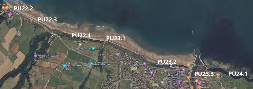
In terms of coastal erosion, the following image is from the Environment Agency (shoreline management plans), with key points marked. Please note that
- at PU22.2, PU22.3, PU23.1, PU23.2, PU23.3 the strategy is “Maintain / Replace” (i.e Sandsend, Whitby)
- at PU23.1 the strategy is “Slow erosion from 20yrs” (i.e Upgang Ravine)
- at PU22.4, PU24.1 the strategy is “Do Not Defend” (i.e the golf course, and Saltwick)
Shellfish Mortality
Around October 2021 it was noted the vast number of shellfish deaths found on the coast between Teesside and Robin Hoods Bay. The government launched an “investigation” into the reported incident. In February 2022, a government press release announced that the mass death was caused by an “algal bloom” – a rapid increase in the population of algae that can release toxins into the water and affect other wildlife. Shortly after the press release was published, another mass death of crabs and lobsters was reported on the same coastline. While an algal bloom in October is implausible, an algal bloom in February is considered impossible. In May, there was another mass stranding of crabs and lobsters on the same beaches with divers reporting the seabed immediately south of the River Tees as a “dead zone” with even the seaweed dying.
A report was published by DEFRA in May, concluding that no single consistent causative factor was found, although there was a harmful algal bloom coinciding with the timings of the original incident; the investigation was closed in March 2022. This “conclusion” is disputed by local fisherman, suggesting that pyridine could be a possible cause since the algal bloom theory did not totally fit the marine biology findings, and so were crowdfunding their own independent report by Tim Deere Jones. The DEFRA work has been passed to Cefas to investigate some aspects further.
The local MP for Scarborough and Whitby asked the Ministry for Fishing to investigate further, and their response is available here. This is an open issue with the UK Government currently having no definitive answer, with the Tees being seen as an important Freeport “experiment”.
Newcastle, York and Hull universities have subsequently performed research into the effect of pyridine on crabs, and the water conditions around the Tees. The conclusions show the devastating impact that pyridine has on shellfish. They have subsequently been invited before the Environment Select Committee in London.
Flooding
Flooding has always been an issue along the River Esk, and in the Harbour area, though it is seemingly becoming more frequent.
Specifically regarding the potential impact of flooding in the Whitby harbour area.
- 2002 – The report by High-Point Rendel says that there is a potential for West Pier and / or East Pier of Whitby Harbour to breach under storm conditions, possibly within the next 10 years or so.
- 2009 – Further investigations by Royal Haskoning confirmed the 2002 study. They stated “(A pier breach) … would lead to increased flooding along the River Esk, disruption or closure of the harbour, loss of access for vehicles to shelter and to service the numerous commercial operations along the river”, together with “A pier breach could have major secondary effects on the levels of risk experienced elsewhere within the study area, especially along West Cliff””. The conclusions, based on 2006 climate change predictions, were
- Emergency work needed to East Pier extension
- Urgently need £8.4m work to rectify condition (Env Agency £4.6m).
- Total need £18m-24m to improve performance for next 50 years.
- Repairs to extensions delayed for up to 20 years.
- 2019-2020 – Repairs to piers completed, £7.6m.
- 2020 – Completion of a £2.1m flood alleviation scheme consisting of a concrete wall along Church Street.
- 2023 – FOI to Env Agency, “what is the flood risk for Endeavour Wharf?” received a reply of “Zone 2”. After challenging this, the response was “Oops, sorry, Endeavour Wharf is Zone 3“.
- 2024 – Repairs to pier extensions are still not in any plan. Cost = £ ??millions. This work would need to be completed by 2031 (based on 2006 predictions). Estimated time to complete would be 2+ years. There is a need to use Endeavour Wharf for HGV access.
Overall in terms of flood risk assessment
- NYMNPA have done strategic flood risk for the River Esk (i.e river flood risk) down to Ruswarp Weir but not beyond.
- DEFRA have done a tidal flood risk assessment for NE Coast and Whitby Harbour.
- NYC Flood Risk Strategy 2022-2027 does not include tidal flood risks.
The Environment Agency and NYC urgently need to undertake a combined flood risk assessment (river + tidal) for Whitby. This should be done before the Town Deal “Maritime Hub” and “Swing Bridge Pedestrianisation” projects go ahead.
The strategic flood risk assessment (SFRA) assesses the different levels of flood risk in Scarborough area. The specific area for Whitby is in this document.
In terms of river basin assessments, there is one performed for the Humber district, and one for the Tees district, but nothing is carried out for the Esk.
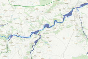
Regarding the Environment Agency flood map for planning purposes, you can see representative flood risk maps below for Whitby, Ruswarp, Briggswath-Grosmont-Egton Bridge, and Glaisdale-Lealholm-Ainthorpe areas
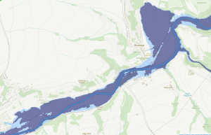

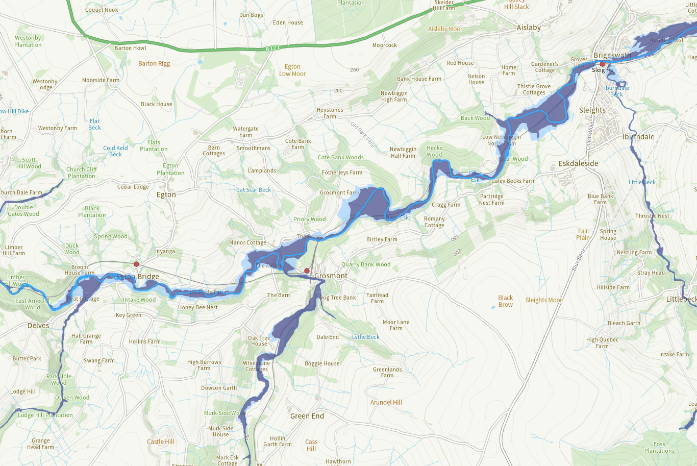
Future Developments?
Whitby Harbour and Piers offer an opportunity for generation of hydro power. A feasibility study took place around 2010 involving Royal Haskoning. You can find the final report here.
Whitby Harbour and Piers offer an opportunity for developing industry around the farming of kelp. A feasibility assessment took place around 2010 involving the Atkins group. You can find it here.
In 2011, Haskoning did a study about having further moorings up the Esk beyond where the old ford was. You can find it here.