The Whitby “Maritime Hub” project came before the North Yorkshire Council Executive Committee on 21/01/2025 to decide whether it should go ahead. Whitby Community Network made one final submission to the relevant people on 13/01/2025. It was as follows.
Dear Councillors and Officers,
The NYC Forward Plan shows that, on 21 January 2025, the NY Executive is due to receive a report about the Maritime Hub on Endeavour Wharf in Whitby harbour. The report will seek Executive approval to enter into a contract with the construction contractor to deliver the agreed works, subject to a viable business case.
The agenda and reports for that Executive meeting have yet to be published, but Whitby Community Network submits that this decision should be deferred to a later meeting. This would allow time for the Council to consider the Environment Agency’s latest assessments of increased flood risks, published in December 2024. The National Planning Policy Framework was also subject to revision in December 2024. Planning decisions must incorporate climate-resilient design principles and strategies to alleviate the impact of extreme weather events.
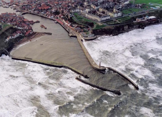
Small, isolated coastal towns are predicted to suffer the effects of climate change more than inland areas. Whitby town and harbour lie on the only tidal estuary in North Yorkshire. The tidal waters of the River Esk extend beyond Endeavour Wharf to Ruswarp weir, which lies some 2km upriver of the harbour mouth, at the boundary with the North York Moors National Park. The tidal reaches of the Esk, together with the inner and outer harbour, are part of the North East Inshore Marine Plan area.
The North East Marine Plan sets out specific policies to inform decision-making for any activity or development which is in, or impacts on, a marine area. The Marine Plan must be used for all planning decisions for the sea, coast, estuaries and tidal waters as well as developments that impact these areas, such as infrastructure. All public authorities are responsible for implementing the North East Marine Plan through existing regulatory and decision-making processes. However, the planning application for the Maritime Hub made no reference to the NE Marine Plan and the proposed development does not appear to comply with several of its policies.
The current NYC Strategic Flood Risk Assessment (SFRA) does not include the risks from sea and tidal flooding. Neither does it consider the non-tidal length of the River Esk beyond Ruswarp, since that SFRA is the responsibility of the North York Moors National Park Authority.
Thus there is no current, accurate assessment of the combined flood risk in Whitby harbour at times of concurrent sea and river flooding. The Environment Agency claims that the new National Flood and Risk Assessment will provide a single picture of current and future flood risk from rivers, the sea and surface water.
The new flood risk forecasts and revised planning guidance on climate change are material considerations in decision-taking. We submit that it would be irrational to take an Executive decision about the Maritime Hub on 21st January, without first allowing sufficient time for consideration of the potential implications for the proposed development of Endeavour Wharf and its compliance with the NE Marine Plan.
A summary of the relevant policies and reports is attached for your consideration.
Yours sincerely
Whitby Community Network CIC
Summary of relevant policies and reports
1. National Flood Risk Assessment and National Coastal Erosion Risk Map [link]
The Environment Agency’s new National Flood Risk Assessment (NaFRA) and National Coastal Erosion Risk Map (NCERM) were issued on 17th December 2024. Much improved local-level data will be made available from the end of January 2025.
The Environment Agency states that:
- The new national assessment of flood risk (NaFRA)
- provides a single picture of current and future flood risk from rivers, the sea and surface water
- uses both existing detailed local information and improved national data
- includes the potential impact of climate change on flood risk
- It provides clearer detail than our current risk assessment on the areas at risk – providing much higher resolution maps that make it easier to see where there is risk.
- The current Risk of Flooding from Rivers and Sea maps are limited by a 50 metre resolution. The better modelling in the new NaFRA provides a 2 metre resolution.
- The new NaFRA will also be able to show characteristics such as: potential flood depths; likelihood and impacts; and the economic damages of flooding.
2. National Planning Policy Framework [link]
A new version of the National Planning Policy Framework was published on 12th December 2024 and includes:
- 231. The policies in this Framework are material considerations which should be taken into account in dealing with applications from the day of its publication. Plans may also need to be revised to reflect policy changes which this Framework has made.
- 163. The need to mitigate and adapt to climate change should also be considered in preparing and assessing planning applications, taking into account the full range of potential climate change impacts.
- 183. In coastal areas, planning policies and decisions should take account of the UK Marine Policy Statement and marine plans. Integrated Coastal Zone Management should be pursued across local authority and land/sea boundaries, to ensure effective alignment of the terrestrial and marine planning regimes.
3. The North East Marine Plan [link]
The North East Marine Plan covers the English inshore and offshore waters from the Scottish border to Flamborough Head. It must be used for all planning decisions for the sea, coast, estuaries and tidal waters (which sometimes extend a long distance inland), as well as developments that impact these areas, such as infrastructure. All public authorities are responsible for implementing the North East Marine Plan through existing regulatory and decision-making processes.
Please note: NE Marine Plan Policy NE-INF-2 states:
- NE-INF-2 (1) Proposals for alternative development at existing safeguarded landing facilities will not be supported.
- 59. Landing facilities are structures, or amenities, that enable the loading or unloading of goods, catch, freight, waste or passengers by vessels (for example, aggregate and waste wharves, slipways, jetties and piers).
- 60. Safeguarded landing facilities are designated sites that protect their functioning for current and future use…
- … safeguarded sites across the north east inshore marine plan area include operational and viable non-operational wharves, which have the potential to be reactivated and their use maximised for waterborne freight handling.
3a. The Whitby Coastal Strategy 2 [link]
The Whitby Coastal Strategy 2 was later incorporated into the NE Inshore Marine Plan. It covered the five kilometres of North Yorkshire’s coastline between Sandsend and Whitby’s Abbey Cliff, and extended two kilometres into the River Esk estuary. The Strategy built on the original Whitby Coastal Strategy (2002); the River Tyne to Flamborough Head Shoreline Management Plan (2009); and a comprehensive suite of investigations at Whitby Harbour (undertaken 2007- 2009).
The Strategy Report 2 was adopted by SBC in 2012 and an application was made to the Environment Agency for Flood and Coastal Erosion Risk Management (FCERM) Grant-in-Aid from central government, in support of the capital costs. The whole life costs of the Strategic Plan over the entire coastal frontage over the next 100 years were estimated at £118m.
The Strategy highlighted the need to maintain the outer harbour structures (main piers and extensions) over the next 100 years since they were critical to the management of the wider coastal area [e.g.by reducing the loss of sand from Whitby beach]. But it also stressed that failure to adequately maintain both the piers and the pier extensions would risk inundation of the whole town centre and the total closure of the port. The very comprehensive report was based on extensive research and modelling and also considered the social, economic and environmental implications, for example:
- 3.3.3 Within the Study Area of Whitby Coastal Strategy 2, there is great inter-connectivity of physical processes and environmental setting across the coastal frontage, the Whitby Harbour piers, and the river frontage. At the centre of these interactions is Whitby Harbour itself, which has a strategic importance within the Study Area, not only socially, economically and environmentally (especially heritage value and earth science heritage value), but also in terms of technical issues related to the physical processes that operate across the Study Area. Management decisions at Whitby Harbour can positively or negatively influence the risks, and potentially can constrain the available management options, along the adjacent coasts and within the inner harbour. For this reason a strategic approach to management of risks within the Study Area is essential.
- 4.2 The consequences of doing nothing are that there would be 776 properties potentially at risk from erosion or instability over the next 100 years. There would be the loss of 53 listed buildings, 68 cultural heritage sites, 21 archaeological sites, 17 Defence of Britain sites and 2 scheduled monuments. The loss of the Harbour Piers would adversely affect the geological SSSI, and 2 conservation areas. There would be loss of tourism and amenity value which is irreplaceable due to the unique tourist appeal of key cultural assets and the iconic location of the Abbey and Harbour setting. A further 159 properties are at risk from sea flooding.
- 5.5.9 Recognising the importance of the Study Area to the UK economy in terms of its tourism and recreational value, driven by its unique visitor product and tourist appeal, a Contingent Valuation Study was undertaken. This identified the annual economic revenue from tourism and recreation, the perceived ‘equivalent value’ enjoyed by visitors to the Study Area, and the reduction in visits should that value be adversely affected by deteriorating coastal, harbour and river defences under a Do Nothing option.
- 5.5.11 Further damages associated with failure of the Whitby Harbour structures under a Do Nothing option were calculated based on the importance of the ongoing functionality of the harbour to the UK economy, as defined by the loss of an important UK harbour refuge (leading to loss of life during North Sea storms), relocation of the RNLI Lifeboat Station, damage to vessels berthed in the harbour, and costs for increased dredging requirements in the harbour channel. Additional losses to harbour-related business of fishing and maritime services, as well as loss of opportunities for marine business associated with the North Sea offshore wind farm developments were considered either qualitatively or, where valid, quantitatively.
Note: Use of Endeavour Wharf
The refurbishment works carried out on the main piers during 2018/19 required the use of Endeavour Wharf as the site compound for the receipt and storage of all HGV deliveries of plant and machinery, plus office and welfare facilities for the construction staff (SBC Planning Decision No 18/00872/RG3 – 14 June 2018). There is no road access to the East Pier and very limited HGV access to the West Pier. Materials and equipment were ferried to/from the appropriate current work sites on the piers, by vessels using the two deep-water berths at Endeavour Wharf.
The repair work could only proceed safely during the limited periods of favourable sea conditions at the harbour entrance. Rapid evacuation was needed at times, hence the need for a site compound situated within the harbour. There is no other suitable location.
Substantial repair and maintenance work on the pier extensions was scheduled for completion by 2032. But the extensions are totally inaccessible by road and are subject to more extreme sea conditions than the main piers. The East Pier extension is the most directly exposed to wave action of all the harbour structures. Major construction work on the extensions will require the extensive and prolonged use of Endeavour Wharf as the site compound. All of the construction plant and materials will need to be delivered by road to the Wharf for storage, pending timely shipment to and from the pier extensions.
The current Shoreline Management Plan identifies the need to “hold the line” in respect of the piers and extensions until the end of this century. Further repair works and the raising or strengthening of these harbour structures may well be required during that period, given the actual increase in sea-levels and extreme weather conditions experienced during the years ahead.
4. The Current NYC Strategic Flood Risk Assessment for Whitby [link]
NYC is the Lead Local Flood Authority (LLFA) for the Whitby area, but this excludes flood risk assessment for the non-tidal length of the River Esk, which is the responsibility of the North York Moors National Park Authority LLFA.
The NYC Local Flood Risk Strategy 2022- 2027 is only required to consider flooding from ordinary watercourses, surface water and groundwater. It does not include the risk of flooding from the sea. Thus there is no current, accurate assessment of the combined flood risk in Whitby harbour at times of concurrent sea and river flooding.
Historically, the most severe flooding in Whitby occurs when extreme weather conditions across the River Esk catchment area result in flood surges down the river, into the tidal reaches, concurrent with exceptionally high incoming tides and an aggressive wave climate. There is a clear and urgent need to produce a combined flood risk assessment for Whitby harbour and the town centre under such conditions.
Whilst we know that this was received by NYC councillors / officers, we did not get a reply. On the 21st January 2025 they voted in favour of going ahead with this project.
We subsequently sent the following letter (on 22nd January 2025), to the same councillors / officers.
22 January 2025
FAIR NOTICE
Re: Executive Decision on 21 January 2025 to enter into a contract with the construction
contractor to deliver the agreed works for the Maritime Hub on Endeavour Wharf, Whitby.
Dear Councillors and Officers
As set out in our letter dated 12 January 2025, we maintain that this decision should have been deferred, to allow sufficient time for consideration of the potential implications for the proposed development on Endeavour Wharf of:
- new Environment Agency flood risk forecasts,
- revised NPPF guidance on climate change,
- and compliance with the NE Marine Plan.
Executive approval was granted, irrespective of such considerations. However, there remains a requirement for a Full Planning Application to be submitted and approved before the whole of Endeavour Wharf car park can be closed to the public, for the duration of the construction, as stated in para. 10.3 of the report submitted yesterday to the Executive [link].
This requirement for a Full Planning Application was alluded to in a footnote to our previous letter, which cited the SBC Planning Decision No 18/00872/RG3 of 14 June 2018. We were unable to locate an on-line reference copy via the NYC website, but have now done so, from the archived SBC material. We have also appended a PDF copy of the main report, for ease of consideration, and trust that we will soon receive a response to both of our letters.
Yours sincerely
Whitby Community Network CIC
We finally received a reply from NYC on 24th February 2025! as follows
Thank you for your letter dated 22nd January 2025 in regard to the Executive Decision for the Whitby Maritime Hub.
The planning application for the Whitby Maritime Hub was determined in line with the planning policy and relevant legislation in place at the time of its consideration in August 2024. The Environment Agency (EA) were consulted throughout the planning process, and a site specific flood risk assessment provided which was assessed by the EA and their views considered.
The design of the building takes into the account it’s location in a flood zone. The Local Planning Authority have confirmed a further planning application is not needed to carry out the construction of the building on Endeavour Wharf. The facility is restricted to water compatible uses which is applicable to maritime related activities. The Executive made its decision based on the relevant information that applies to the Whitby Maritime Hub. The Town Deal Board and the Council will continue to keep the community informed throughout the build through our media outlets.
Consequently not addressing many of the points raised, particularly the ignorance of the National Planning Policy Framework and the Marine Plan and still building on a registered cargo wharf. This is particularly pertinent given the High Court judgement that this area IS harbour land.